The GIS Hub (or Godot InSim Hub) is, as its name implies, a hub application for Godot InSim. Its main goal is to provide a common interface for multiple Godot InSim apps to interface with LFS via a single InSim connection - which means you can have as many "apps" running as you want, sharing the same InSim connection, instead of being limited to the 8 connections LFS supports.
This allows the hub app to be the only "heavy" part, as a single Godot executable (and its ~80MB) is necessary here; all Godot InSim apps can instead be distributed as "modules", as small .pck files, and run directly in GIS Hub.
GIS Hub provides the following features:
These 2 modules are considered "core": they are included in the GIS Hub app, and cannot be disabled. You can however disable logging through the Log module's options.
All other modules, including those distributed with GIS Hub, can be enabled or disabled at any time. Adding a module is as simple as dropping a .pck file in the "modules" folder next to the GIS Hub executable.
Modules can write config and data in their dedicated folder, located in the "user://modules" directory, which corresponds to:
Downloads and documentation:
GIS Hub is available on the GitLab repository. To use it, simply download it along with the modules you want, drop the modules in the modules folder, and you're good to go. If you intend to develop modules, you will need to download the Godot editor, as well as Godot InSim itself (you can pull it as a submodule from GIS Hub).
I highly recommend that you read through the dedicated documentation website, which includes a user guide and multiple guides for module developers. The public API is also documented inside the Godot editor, and you can read the source code of both core and other modules for reference.
Provided modules:
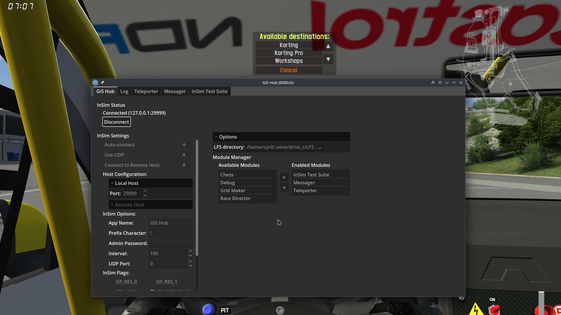
GIS Hub: [Core] This module provides the main interface for InSim settings and module management.
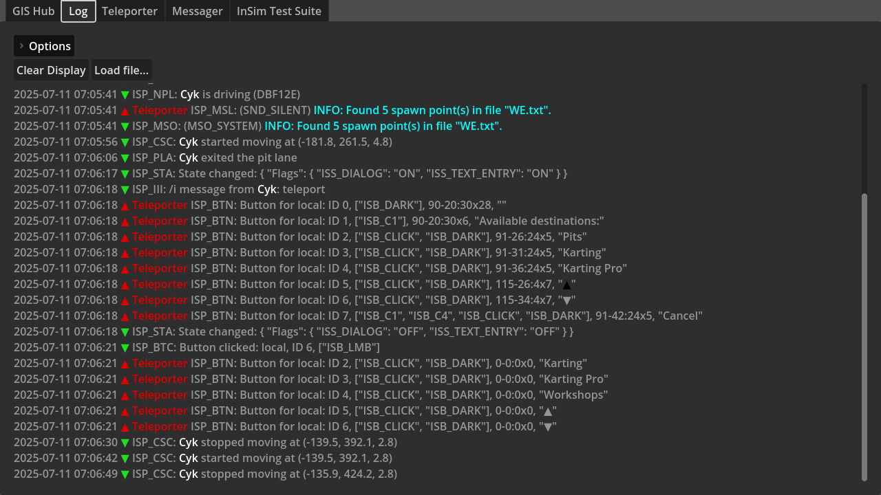
Log: [Core] This module displays all InSim packet traffic, including timestamps, packet direction (and the sender module if relevant), and a human-readable version of the packet contents (which may omit some data, depending on the packet type). It also creates a log file with the full data for all packets, and allows loading such files back into its GUI for easier reading.
Log options include color management for log files (none, ANSI, BBCode), whether to log files to screen and/or file, and whether to include NLP/MCI packets.
InSim Debug: This module can help debug the current state of the InSim connection. At this time, its only feature is button debugging: you can see what clickIDs are being used, and what buttons are being tracked and displayed for each player. You can also display a preview of each button.
Teleporter: This module provides the "teleport" command to display a simple InSim button GUI allowing to choose a teleport destination. Such destinations can be included in a "track.txt" file according to the format in the provided examples, and files should be named according to the track they are intended for (e.g. "BL1.txt", "SO4R.txt"), or only the first 2 letters for open configs (e.g. "WE.txt" instead of "WE1X.txt").
The "teleport" command can be typed either as "/i teleport" or using the InSim connection's prefix ("!teleport", "@teleport", or any other prefix character).
Messager: This module provides a simple text entry GUI allowing you to type messages directly in UTF8, without having to go through the multiple LFS character pages. You can also easily change text color on the fly without having to retype text, and you can also mention someone using the list of connected players, just like you would in the game.
Do note that LFS has poor support for UTF8, despite the addition of code pages for multiple languages, so many characters are not supported and will produce garbage.
Additional planned features include saving shortcuts to custom messages and message history. Providing a virtual keyboard to show characters from some code pages, as you can see in LFS, is very unlikely to happen.
InSim Test Suite: This one is not exactly meant to be used by standard users, but can be used to track sent and received InSim packets, as well as send packets by clicking on the corresponding buttons, for testing purposes.
This allows the hub app to be the only "heavy" part, as a single Godot executable (and its ~80MB) is necessary here; all Godot InSim apps can instead be distributed as "modules", as small .pck files, and run directly in GIS Hub.
GIS Hub provides the following features:
- Manage a single InSim connection to use with any number of modules (practical limit is 50)
- Manage modules (discover on startup, hot enable/disable), with active modules arranged as tabs in the GUI
- Save and load module configuration, including InSim settings and enabled modules, and give access to a per-module data folder
- Route packets from LFS to all modules and the other way around
- Mirror Godot InSim functions for sending packets, managing InSim buttons, etc. at the module level (wrapper functions)
- Callback functions for all InSim packets, ISP_TINY/ISP_SMALL packet subtypes, and Relay packets
- Inter-module communication with the ability for a module to send arbitrary data, and subscribe to other modules to handle data they send
- Graphical interface for included modules (InSim settings and module manager, log module, etc.), and all modules can provide their own GUI
These 2 modules are considered "core": they are included in the GIS Hub app, and cannot be disabled. You can however disable logging through the Log module's options.
All other modules, including those distributed with GIS Hub, can be enabled or disabled at any time. Adding a module is as simple as dropping a .pck file in the "modules" folder next to the GIS Hub executable.
Modules can write config and data in their dedicated folder, located in the "user://modules" directory, which corresponds to:
- Windows: "%APPDATA%\Godot\app_userdata\GIS Hub\modules\<module name>"
- Linux: "~/.local/share/godot/app_userdata/GIS Hub/modules/<module name>"
Downloads and documentation:
GIS Hub is available on the GitLab repository. To use it, simply download it along with the modules you want, drop the modules in the modules folder, and you're good to go. If you intend to develop modules, you will need to download the Godot editor, as well as Godot InSim itself (you can pull it as a submodule from GIS Hub).
I highly recommend that you read through the dedicated documentation website, which includes a user guide and multiple guides for module developers. The public API is also documented inside the Godot editor, and you can read the source code of both core and other modules for reference.
Provided modules:
GIS Hub: [Core] This module provides the main interface for InSim settings and module management.
Log: [Core] This module displays all InSim packet traffic, including timestamps, packet direction (and the sender module if relevant), and a human-readable version of the packet contents (which may omit some data, depending on the packet type). It also creates a log file with the full data for all packets, and allows loading such files back into its GUI for easier reading.
Log options include color management for log files (none, ANSI, BBCode), whether to log files to screen and/or file, and whether to include NLP/MCI packets.
InSim Debug: This module can help debug the current state of the InSim connection. At this time, its only feature is button debugging: you can see what clickIDs are being used, and what buttons are being tracked and displayed for each player. You can also display a preview of each button.
Teleporter: This module provides the "teleport" command to display a simple InSim button GUI allowing to choose a teleport destination. Such destinations can be included in a "track.txt" file according to the format in the provided examples, and files should be named according to the track they are intended for (e.g. "BL1.txt", "SO4R.txt"), or only the first 2 letters for open configs (e.g. "WE.txt" instead of "WE1X.txt").
The "teleport" command can be typed either as "/i teleport" or using the InSim connection's prefix ("!teleport", "@teleport", or any other prefix character).
Messager: This module provides a simple text entry GUI allowing you to type messages directly in UTF8, without having to go through the multiple LFS character pages. You can also easily change text color on the fly without having to retype text, and you can also mention someone using the list of connected players, just like you would in the game.
Do note that LFS has poor support for UTF8, despite the addition of code pages for multiple languages, so many characters are not supported and will produce garbage.
Additional planned features include saving shortcuts to custom messages and message history. Providing a virtual keyboard to show characters from some code pages, as you can see in LFS, is very unlikely to happen.
InSim Test Suite: This one is not exactly meant to be used by standard users, but can be used to track sent and received InSim packets, as well as send packets by clicking on the corresponding buttons, for testing purposes.